Corrective Measures Implementation of the Selected Remedy
Pacific Gas and Electric Company (PG&E) prepared a Work Plan (the Groundwater Corrective Measures Implementation/Remedial Design [CMI/RD] Work Plan for Solid Waste Management Unit [SWMU] 1/Area of Concern [AOC] 1 and AOC 10) with design schedules to implement the remedy. Based on the format and schedule outlined in the Work Plan, PG&E submitted the Basis of Design/Preliminary (30%) Design on November 18, 2011. On April 5, 2013, PG&E submitted the Basis of Design Report/Intermediate (60%) Design document. On September 8, 2014, PG&E submitted the Basis of Design Report/Pre-Final (90%) Design document. On November 18, 2015, PG&E submitted the Final (100%) Design document for approval. The Final (100%) Design Report included comments received on the 90% and the Supplemental design. An errata was submitted on November 18, 2016 and an addendum to fhe flow and solute transport model was submitted on January 9, 2017.
DOI approved the final design on April 3, 2018. DTSC approved the final design after certification of the groundwater remedy Final Subsequent EIR on April 24, 2018.
Freshwater Investigation for the Final Remedy
The final remedy will require a supply of freshwater. On January 28, 2013, PG&E submitted an Implementation Plan for Evaluation of Alternative Freshwater Sources in the Topock Remediation Project Area to identify the most appropriate freshwater source. On September 4, 2013, the California Department of Toxic Substances Control (DTSC) and the U.S Department of the Interior (DOI)The United States department charged with conservation and development of natural resources. The U.S. Department of the Interior uses sound science to manage and sustain America’s lands, water, wildlife, and energy resources, honors our nation’s responsibilities to tribal nations, and advocates for America’s island communities. approved the implementation plan, which proposed installation and evaluation of new water supply wells in Arizona. See the figure below for the freshwater source locations. A Summary of Findings Associated with the Evaluation of Alternative Freshwater Sources in the Topock Remediation Project Area, Pacific Gas and Electric Company, Topock Compressor Station, Needles, California was submitted April 2, 2014. Based on these findings, PG&E conducted additional field activities which were completed mid-July 2014. An addendum to the above-mentioned report was included as an appendix in the Pre-Final (90%) Design report and the Final (100%) Design published November 18, 2015, and can be found here.
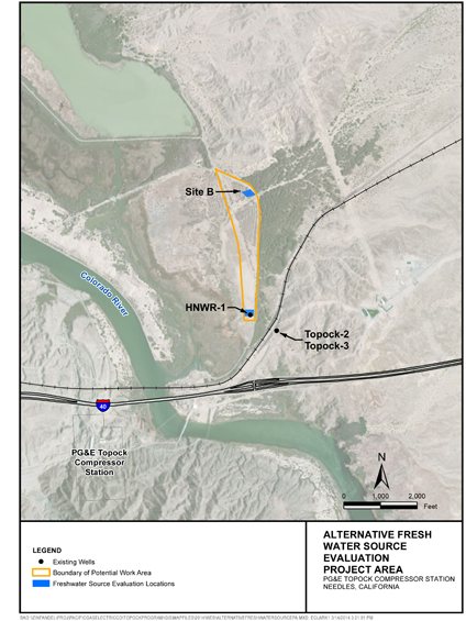
(Click on image above for larger view)
Protection of Cultural and Biological Resources
The Topock Project Site (Site) is part of a larger geographic area that is considered sacred by some Native American Tribal Nations. In the 2011 Final EIR, DTSC concluded that the 779.2‐acre Site “appears to qualify as a historic resource under the California Environmental Quality Act as an area that is significant in the social and cultural annals of California,” and the U.S. Bureau of Land Management (BLM) also has determined that a traditional cultural property or property of traditional religious and cultural significance that is eligible for listing in the National Register of Historic Places exists in the area of the Site, within the current Area of Potential Effect, consisting of 1,600 acres of surface area and a section of the Colorado River. Among the larger and better known cultural resources on the Site is an expansive desert geoglyph or intaglio known as the Topock Maze.
Prominent historic‐era features in the landscape also overlie the groundwaterWater beneath the Earth’s surface that flows through soil and rock openings (aquifers). plumeA body of contaminated groundwater. The movement of a groundwater plume can be influenced by such factors as local groundwater flow patterns, the character of the aquifer in which the groundwater is contained, and the density of contaminants., include segments of historic U.S. Route 66, the National Trails Highway (also known as the National Old Trails Highway), and the right-of-way of the BNSF Railway. A broad spectrum of archaeological resources are also present within the Site and on adjacent lands. Properties on and near the Site that are eligible for or listed in the National Register of Historic Places include Native American cultural resources and elements of the historic “built environment.”
For these reasons, all remedial activities at the Topock Compressor Station are planned in such a way as to minimize impact to this area. Impacts to cultural and archaeological/historical and biological resources will be minimized by implementing the mitigation measures required by the Mitigation Monitoring and Reporting Program (MMRP) adopted by DTSC in 2011 as part of the certified EIR, which was updated in the 2018 certified Final Subsequent EIR, as well as measures under the Programmatic Agreement, the Cultural and Historic Properties Management Plan, and in consultation with Tribal Nations throughout the investigative and remedial activities.
A large portion of the Site and surrounding area is within the Havasu National Wildlife Refuge. Portions of the Site are also located in a Riparian and Cultural Area of Critical Environmental Concern and the Topock‐Needles Special Cultural Resource Management Area, designated under the BLM Resources Management Plan. Impacts to biological resources will also be minimized by implementing the mitigation measures required by the MMRPs, Programmatic Biological Assessment (PBA), the Avoidance and Minimization Measures required by the California Department of Fish and Wildlife, as well as compliance with Applicable or Relevant and Appropriate Requirements included in the DOI’s Record of Decision.
PG&E is working closely with biologists to ensure appropriate measures are taken to protect sensitive desert habitat during all aspects of Project implementation. A PBA was completed in January 2007 to cover remediation and investigation projects at the Site up to the final groundwater remedy. On December 27, 2012, the 2007 PBA was modified and extended for 5 years (until 2017). On April 12, 2018, the 2007 PBA was modified and extended an additional 10 years (until 2027). Authorization for the extension and modification of the 2007 PBA can be found here. A PBA was submitted on April 28, 2014, and covers activities related to implementation of the groundwater remedy. The 2007 and the 2014 PBA can be found here. For habitat improvement, mesquite trees were planted by PG&E on the Havasu National Wildlife Refuge and a drip irrigation system was installed to ensure their survival.
In November and December 2018, as part of groundwater remedy construction, PG&E transplanted 193 individual sensitive plants (palo verde, mesquite, smoketree, and cactus) from the Construction Headquarter (CHQ), Soil Processing Yard (SPY), and MW-20 Bench, and planted those plants in the approved transplantation area off National Trails Highway (NTH). An assessment of the health of transplanted plants was conducted in March 2019, and a high mortality rate was observed. Replacement plantings for transplants that did not survive will coincide with the mitigation plantings for sensitive plants that were removed and not transplanted during construction.
PG&E began to collect native seeds for use in mitigation planting in June 2021 and continued into fourth quarter 2021. Seeds were propagated at a nursery and grown into container plants. In December 2021, PG&E began to prepare the mitigation planting areas in the floodplain, south of BNSF Railroad bridge for future mitigation planting. Site preparation activities included the removal of tamarisk debris and root balls, off-site disposal of debris, installation of an irrigation system, leaching of soluble salts from the soil for the establishment of the new plants, and installation of fences to protect plants. After fence installation, plants grown from the collected seeds were placed into the ground in March 2022. In addition, fence installation and cactus and shrub planting at an uplands mitigation planting area occurred in April 2022.
PG&E is conducting O&M activities in the mitigation planting areas which include weed abatement (e.g., manual weed removal, herbicide application, etc.), drip irrigation and maintenance of system, plant health monitoring and census, and soil sampling.
PG&E continues to coordinate with CDFW and DTSC on the compensatory mitigation plan to address temporal loss of jurisdictional ephemeral waters impacted by groundwater remedy construction.
Surveys and monitoring to ensure biological and cultural resource protection will continue to be a priority as investigative and remedial activities progress at the Site. A listing of recent surveys and monitoring activities is provided here.